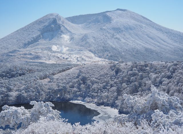
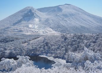
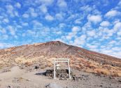
EBINO PLATEAU
ABOUT EBINO PLATEAU

Up close and personal
with an active volcano
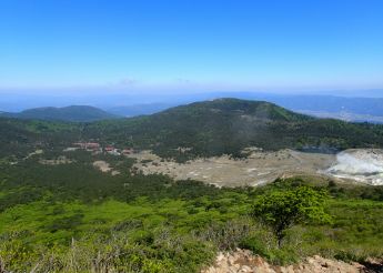
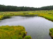
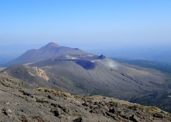
On the Ebino Plateau, the explosion crater of Mt. Karakuni, the steaming vents of Mt. Iwo, crater lakes like Lake Rokkannon-miike and Lake Byakushi-ike are among the highlights of the volcanic landscape.

Volcanic activity creates
a diverse ecosystem
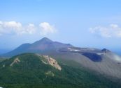
The Kirishima region is the only location on Earth that is home to nokaido crab apples and the Miyama kirishima Kyushu azalea, which turn the mountainside pink. The diverse landscape hewn by volcanic activity is a rich habitat for flora and fauna.
SURROUNDING
MOUNTAINS
-
-
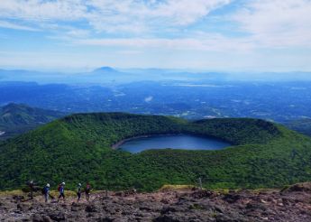
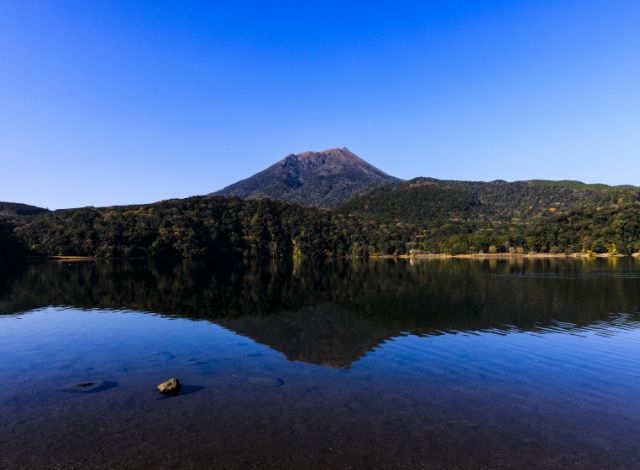
01 Mt. Karakuni The 1700m, highest peak of the Kirishima area
-
01 Mt. Karakuni The 1700m, highest peak of the Kirishima area
- Elevation
- 1,700m
- Distance
- It is around 2km to the summit from the Ebino Plateau trailhead
- Standard time
- Up: 1h 30
Down: 1h
Here at the highest point of the Kirishima area is a crater of 900m in diameter and a depth of 300m. From Ebino Plateau, the stout form of the mountain resembles a large tub. It is a mountain with a violent history, as seen in the giant rockfaces of the decaying crater. From the top of the mountain, you can see the whole of the Kirishima area with its many craters formed by volcanic activity. To the southeast are Mt. Shishiko, Mt. Shinmoe, Mt. Nakadake, Mt. Ohachi and Mt. Takachihonomine, the most famous peaks of the Kirishima area. Mt. Karakuni (which uses the same characters as those for Korea) is said to have been named after "Kara no Kuni" (the Korean peninsula) because it is so high, it afforded views all the way to Korea.
- Mt. KarakuniHighlights
-
Mt. Shinmoe and Mt. Takachihonomine as seen from Mt. Karakuni The slopes of the mountain feature native forest trees such as Japanese fir, southern Japanese hemlock and red pine.
Above is scrub forest including Japanese green alder, Hydrangea paniculata and Rhododendron kiusianum.
The summit also provides a good view of the Mt. Shinmoe crater, which is currently in an active phase.
-
-
-
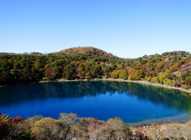
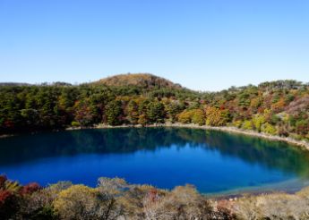
02 Lake Onami-ike Renowned for the beauty of its spring greenery and autumn foliage
-
02 Lake Onami-ike Renowned for the beauty of its spring greenery and autumn foliage
- Elevation
- 1,411m
- Distance
- It is 1.25km from the Lake Onami-ike trailhead on Prefectural Route 1 to the summit
- Standard time
- Up: 40 mins
Down: 30 mins
At an elevation of 1411m is a stunning crater lake of 1.9km circumference and 11m deep.
Onamino-ike is the site of the Onami legend.
The trail to the top runs through a forest of Japanese fir and southern Japanese hemlock, and the crater loop trail takes around 2 hours.- Lake Onami-ikeHighlights
-
The spring greenery of the Lake Onami-ike crater walls 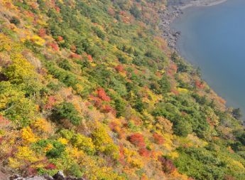
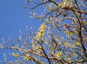
Japanese witch hazel (from the Onami-ike trail) Blooming in late March, the Japanese witch hazel growing on the crater walls proudly announces that spring has come to the Kirishima area. Then from late May the new greenery makes a stunning contrast with the lake waters, as does the autumn foliage of early November, making this a very popular mountain.
-
-
-
03 Mt. Shiratori Offers superb views of the Kirishima area
-
03 Mt. Shiratori Offers superb views of the Kirishima area
- Elevation
- 1,363m
- Distance
- Around 2km along the way from Ebino Plateau to Ebino Observatory
- Standard time
- Around an hour along the way from Ebino Plateau to Ebino Observatory
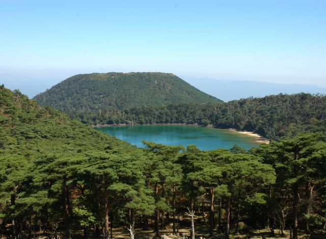
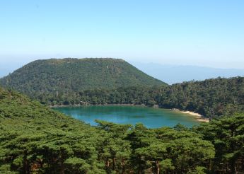
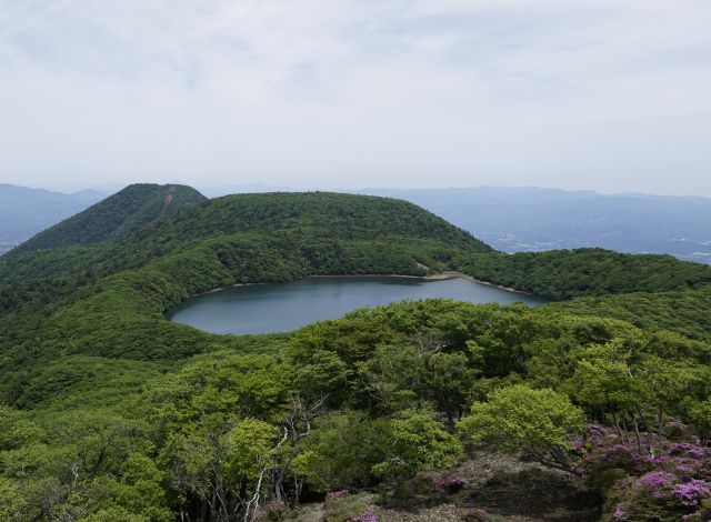
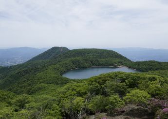
It is a 2-hour walk along the nature trail from Ebino Plateau. The Niko (Two Lakes) Panorama Observatory on the way up the mountain offers views of Lake Rokkannon-miike and Lake Byakushi-ike.
- Mt. ShiratoriHighlights
-
Landscape from the summit of Mt.Shiratori From the summit, you can get a feel for the volcanic landscape of the Kirishima area, with views of Mt. Karakuni, the highest peak, Mt. Koshiki, Lake Byakushi-ike and Lake Rokkannon-miike.
-
-
-
04 Mt. Koshiki The city and Kakuto Caldera can be viewed from
-
04 Mt. Koshiki The city and Kakuto Caldera can be viewed from
- Elevation
- 1,301m
- Distance
- 1.4km from the Mt. Koshiki trailhead
- Standard time
- Around 1 hour each way from Ebino Plateau
Located at the northeast of the Ebino Plateau. Mt. Koshiki's eastern flanks are covered in native forest such as Japanese fir. The coniferous forest is a designated national treasure. Just before the summit the trail is very steep, but the walking is otherwise easy. Coming down from the summit to the crater, a beautiful wetland vista reveals itself. There is also an hour-long trail that skirts the crater. At one point the trail offers a panorama of Ebino City as well as the Kakuto Caldera, which is at the northwest of the Kirishima area.
- Mt. KoshikiHighlights
-
Inside the crater Inside the crater are fields of susuki grass and ponds.
A trail circumnavigates the crater and offers views of the towns at the foot of the mountain and of Kakuto Caldera.
-
-
-
05 Mt.Iwo Covered in beautiful Miyama rhododendrons in early summer
-
05 Mt.Iwo Covered in beautiful Miyama rhododendrons in early summer
- Elevation
- 1,310m
- Distance
- From the Mt. Karakuni trailhead: 600m
- Standard time
- From the Mt. Karakuni trailhead: 20 mins
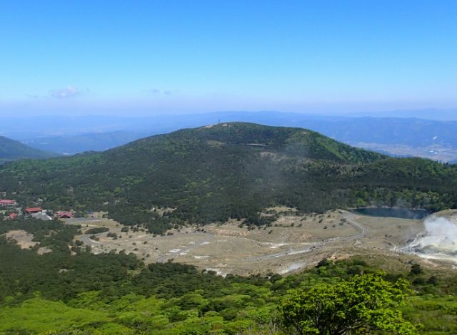
This peak is located at the east of Ebino Plateau, relatively close to the road.
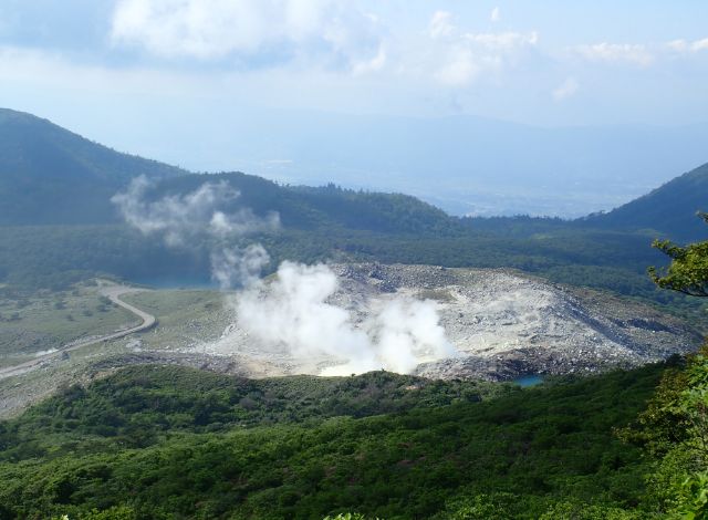
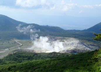
The mountain has a yellow or sulfur-yellow hue, due to the emission of volcanic gases containing hydrogen sulfide and sulfites up to about 20 years ago.
From the Meiji period to the mid-1950s, sulfur was mined here for the production of matches, and the fume vents from the mining can still be seen today.
Vegetation is returning now that the volcanic gases have stopped venting.
In early summer, Kyushu azalea beautify the slopes of the mountain, making this a popular stop.
Due to the eruption in April, 2018, refrain from approaching the crater.- Mt.IwoHighlights
-
Also known as Sai-no-Kawara, the rocks in the area around the summit are whitened by the fumes emitted from the volcano.
It is a one-hour return journey from Ebino Plateau, with beautiful views on a fine day.
-
-
-
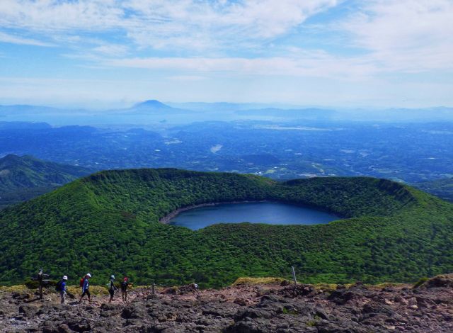
06 Mt. Takachihonomine Site of the legend of the Sun Goddess' grandson descends to Earth

-
06 Mt. Takachihonomine Site of the legend of the Sun Goddess' grandson descends to Earth
- Elevation
- 1,574m
- Distance
- 2.65km
- Standard time
- Takachiho-gawara Visitor Center, Kogushi, Ohachi-kakoen/Uma-no-se, Mt. Takachihonomine
Up: 2h
Down: 1h
This mountain is renowned as the spot where the grandson of the Sun Goddess is said to have descended to earth from the heavens in the first stage of "Tenson korin," an episode in Shinto mythology. The mountain is expressive of the character of the Kirishima mountain range, in both its historical associations and the formation of the mountain itself. With vegetation scarce on the mountainside, the reddish-brown earth presents a constantly-changing panorama of color from morning to evening.
The summit of Mt. Takachihonomine features "Amanosakahoko," a legendary spear which features in the "Tenson korin" of Shinto mythology.
Over the New Year period, the peak of the mountain is busy with people who come to watch the first sunrise of the new year from the summit.
The mountain is also a much-loved spot in early summer, when its slopes are bright with flowering azalea.- Mt. TakachihonomineHighlights
-
Mt.Takachihonomine Visitors can currently observe the mountain covered in lapilli, a kind of volcanic rock that was brought forth by the eruption of Mt. Shinmoe at the end of January 2011. As there is almost no plant growth on the mountain's slopes, insects buoyed up by upward air currents can be seen swarming around the peak of the mountain in large numbers, a phenomenon that cannot be observed anywhere else in the Kirishima mountain range.
-
-
-
07 Mt. Hinamori Beautifully conical shape, earning it the nickname "Ikoma-Fuji"
-
07 Mt. Hinamori Beautifully conical shape, earning it the nickname "Ikoma-Fuji"
- Elevation
- 1,344m
- Distance
- 4.1km from the trailhead
- Standard time
- From the Mt. Hinamori trailhead:
Up: 3h 30
Down: 3h
Located to the north of Mt. Kirishima, this mountain is covered with forests. Known as "Ikoma-Fuji" due to its beautiful conical shape in deepest green when viewed from Kobayashi City, Mt. Ikomafuji has been renowned for its beauty since ancient times. From the summit, the Kirishima mountain range can be glimpsed between the trees. The footpath leading from the summit to Mt. Maruokayama is planted with beeches and Japanese oaks; the beauty of the fresh green leaves and autumn foliage along this path make this a much-loved spot.
- Mt. HinamoriHighlights
-
When you reach the top of the mountain, you can see the east side of Kirishima mountain.
-
-
-
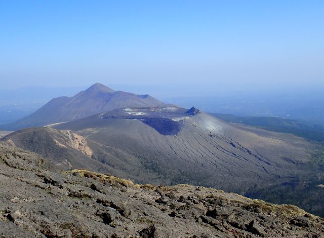
08 Mt. Shinmoe A large crater of 750m diameter
-
08 Mt. Shinmoe(currently off-limits) A large crater of 750m diameter
- Elevation
- 1,700m
- Distance
- 3.7km from Takachiho-gawara
- Standard time
- From Takachiho-gawara
Up: ー
Down: ー
This mountain is located to the northwest of Mt. Nakadake, rising up roughly in the center of the Kirishima mountain range.
An almost perfectly circular crater, 750m across and 180m deep, lies at the top of the mountain. This crater was once home to an emerald-green crater lake (150m from side to side, 30m deep) which used to be a popular attraction, but which no longer exists since the eruption that took place on 26 January 2011 (the first eruption to take place in nearly 300 years since the "Kyoho eruption" of 1716-1717 in the mid-Edo period).
The footpath leading to Mt. Shinmoe is currently off-limits due to volcanic activity.- Mt. ShinmoeHighlights
-
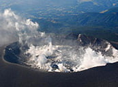
Mt. Shinmoe from the air An extruded lava rock south of the summit is called "Rabbit‘s Ear." Looking from afar, vegetation around the crater has been burned off by the eruptions, but the recovery over time will be a sight to see.
-
-
-
09 Lake Ohata-ike A popular place to see the autumn foliage reflected on the surface of the water
-
09 Lake Ohata-ike A popular place to see the autumn foliage reflected on the surface of the water
- Elevation
- 1,306m
- Distance
- 4.0km from Hinamoridai
- Standard time
- 2h 30 from Hinamoridai
565m across and 14m deep.
The near-perfect circular crater was formed by an explosive eruption.
A low hill of pyroclastic deposits has formed the round shape of a crater (maar), then filled with water to create a crater lake.- Lake Ohata-ikeHighlights
-
This is a popular spot because visitors can hike down to the edge of the lake, and in autumn the foliage reflects beautifully on the surface.
The trailhead is found in the Hinamori Auto Camping Ground, so this is a recommended trip for campers.
-
-
-
10 Lake Fudo-ike The sparkling cobalt blue
-
10 Lake Fudo-ike The sparkling cobalt blue
- Elevation
- 1,228m
- Distance
- 0.6km from Ebino Plateau
- Standard time
- 10 mins from Ebino Plateau
Lake Fudo-ike is a crater lake 200 meters in diameter and 9m deep located in the northwest of Ebino Plateau.
Its waters are mildly acidic as it is fed from Mt. Iwo.
The lake can be viewed from Route 1 and is bustling with visitors.- Lake Fudo-ikeHighlights
-
Due to its acidity, the lake‘s surface sparkles cobalt blue on fine days.
Its accessibility from the road makes this an easy stop for many travelers.
-
-
-
11 Mt. Kurino Popular trails weaving through beech forest
-
11 Mt. Kurino Popular trails weaving through beech forest
- Elevation
- 1,094m
- Distance
- 6.1km from the Mt. Kurino trailhead
- Standard time
- Up: 1h 30
Down: 1h 30
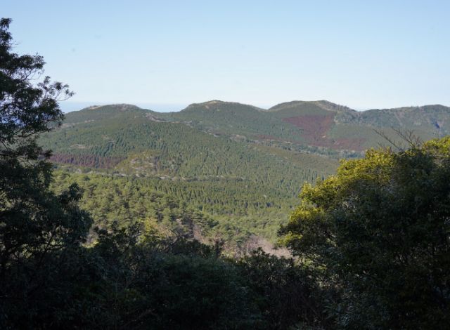
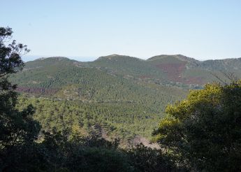
Mt. Kurino is a massif made up of several volcanoes at the far west of the Kirishima area. It is one of the old volcanoes that first erupted following the large eruption that formed the Kakuto Caldera some 340,000 years ago. Over the long period since its formation, Mt. Kurino has eroded and its form has diminished. As an old volcano, Mt. Kurino is covered in vegetation, with fairly high stands of trees near the summit.
- Mt. KurinoHighlights
-
The beech forest along the Mt. Kurino trail is popular for its beautiful greenery in early summer and its colorful foliage in autumn.
-
-
-
12 Lake Miike A great spot for birdwatching
-
12 Lake Miike A great spot for birdwatching
- Elevation
- 305m
- Distance
- 3.9km
- Standard time
- 1h 30
The deepest crater lake in Japan at 1km across, 4.3km in circumference and 103m deep, Lake Miike was created by a
phreatomagmatic eruption which took place around 4,600 years ago. The pumice stone which is produced when eruptions occur is also known as "lake earth" in Japanese; large deposits of this have long been found in in Takahara-cho and are currently seen in the center of Miyakonojo as well.
There are seven ports on the lake: Matsu Port, Mukurasemi Port, Oji Port, Urugizaki Port, Karukaya Port, Yanagi Port and Gomadan Port. Oji Port ("The Prince’s Port"), which currently has a boat platform, is said to have acquired its name from the legend that Emperor Jinno, the first emperor of Japan, played on the shore here as a young child.
There is also a legend about a "shinryu" (divine dragon) associated with this lake. According to "Sangoku Meishozue" (Geography of Southern Kyushu), a book about scenic spots written in 1843, a priest called Shoku Shonin (910–1007), who established a mountain temple in Mt. Kirishima, described how a nine-headed divine dragon appeared to him while he was engaged in religious training on the banks of the river, whereupon Shoku offered a jewel to the dragon.- Lake MiikeHighlights
-
The National Lake Miike Wild Bird Forest centered on the lake attracts birdwatchers in every season of the year.
The lakefront also features a campground, and waterfowl such as Mandarin ducks, common teal and Baikal teal are among the many birds that are found here.
-


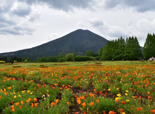
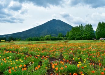
FOUR SEASONS


SPRING Colorful wildflowers and birdsong on the plateau
Japanese witch hazel (hamamelis) and fragrant witch hazel (Corylopsis glabrescens) start to bloom and cover the mountain slopes in yellow, signaling the start of the active season for animals. Woodpeckers tap away at the trunks while small birds reveal beautiful birdsong at the treetops.


SUMMER The season of the rhododendron that symbolizes Kirishima
Early summer is the season of the Rhododendron kiusianum, the most famous flower of the Kirishima area. The song of the cuckoo rings out all over the Ebino Plateau. This is the busiest season for wildlife. In midsummer the cool breeze of the plateau is most pleasant, making this the perfect getaway from the heat everywhere else.


AUTUMN The dazzling contrast of autumn foliage and crater lakes
Look up at the beautiful leaves. At your feet, the colorful blooms of the Japanese gentian and assorted mushrooms. In the evening, the roar of stags pierces the silence across the plateau. The azure crater lakes contrast beautifully with the forest that surrounds them.


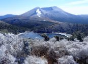
WINTER A frozen silver landscape
The season of the rime ice that creates artistic natural forms. The frozen vista from the top of Mt. Karakuni is breathtaking for its cold and its beauty. The serene hush of the early morning is so quiet you can hear your own heartbeat.